USA Map Separated States Vector: Your Ultimate Design Asset
When you're working on a project that requires a clear, professional, and highly functional map of the United States, the search for the right asset can be surprisingly frustrating. You need something that is not only visually appealing but also versatile enough to adapt to any design system you throw at it. That is exactly where the USA Map Separated States Vector collection comes into play. This isn't just a static image of a map; it is a comprehensive toolkit designed for modern creators who need precision and flexibility. Whether you are building an infographic for a marketing report, designing a website interface, or creating educational materials, having a high-quality vector file is non-negotiable.
The Anatomy of a Versatile Map Collection
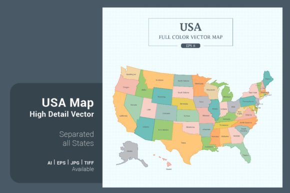
One of the standout features of this product is the sheer variety of styles included. It is rare to find a single package that covers so many aesthetic bases without compromising on quality. The collection includes a full color separated all states version, which is perfect for projects that require distinct visual separation between regions. This style is often the go-to for corporate presentations or social media graphics where you need to grab attention quickly.
However, if you are working with a more limited color palette or need a cleaner look, the mono color separated all states option is invaluable. It maintains the individual state separations but uses a single hue, making it incredibly easy to match to your specific brand guidelines. For those who prefer minimalism, the outline separated all states style offers a skeletal view of the country. This is particularly useful for web design backgrounds or as a subtle watermark on stationery. The inclusion of specific variations like the Map Flag and Outline border on green background (reminiscent of a chalkboard) shows a deep understanding of current design trends, particularly in the education and hospitality sectors.
Technical Specifications That Matter
In the world of digital design, file specifications often determine whether an asset is usable or a waste of time. The USA Map Separated States Vector delivers on the technical front with a massive resolution of 5000x5000 pixels (42x42 cm or 16.5"x16.5"). This square format is incredibly strategic. It aligns perfectly with social media platform requirements, particularly Instagram posts and Facebook graphics, eliminating the need to crop or awkwardly fit a rectangular map into a square frame.
The file formats provided—.AI8, .EPS8, .JPG, .TIF—ensure compatibility with virtually every design software on the market. Whether you are an Adobe Illustrator power user or prefer working in Photoshop, the vector nature of the .AI and .EPS files means you can scale the map to the size of a billboard or a postage stamp without losing a single pixel of clarity. This scalability is the core advantage of using a premium font or asset approach to map design; it future-proofs your work.
Practical Applications for Creatives and Professionals
The true value of a design asset lies in its application. For entrepreneurs and small business owners, this map is a powerful tool for visualizing service areas, shipping zones, or store locations. Instead of using generic clip art, using a high-resolution, customizable map elevates your brand identity and conveys professionalism. Imagine a "Find a Store" page on a website that uses the Outline border on white background style—it feels clean, modern, and trustworthy.
For marketers and content creators, the map serves as a foundation for data visualization. You can easily assign different colors to states to represent market penetration, election results, or demographic data. Because the states are separated, animating them for a video presentation or interactive web element becomes a much simpler task. Bloggers and publishers can use the Square shape versions for Pinterest graphics, which are crucial for driving traffic in the travel and lifestyle niches.
Customization and Ease of Use
A common hurdle with complex graphics is the difficulty of customization. This collection addresses that by offering files that are simple to customization. You don't need to be a vector graphics expert to change the colors of individual states or adjust the overall size. The separation of states means you aren't locked into the creator's color choices; you have full control to match the map to your specific project's color theory.
Consider the Outline border on green background (blackboard) style. While it looks great out of the box, you might want to change that green to a deep navy for a vintage feel. With a vector file, that is a two-second fix. This flexibility makes the asset suitable for a wide range of projects, from packaging design for American-made goods to editorial design for magazines discussing national trends.
Enhancing Visual Hierarchy and Readability
In web design and infographic creation, visual hierarchy is paramount. You need to guide the viewer's eye to the most important information first. By using the Mono color separated all states style as a base, you can highlight specific states with a contrasting color to create an instant focal point. This technique is far more effective than a cluttered, multi-colored map where every state screams for attention.
Furthermore, the clarity of these vectors ensures readability. Even at smaller sizes, the distinct separation of states prevents the "blob" effect that often plagues low-resolution maps. This is crucial for mobile viewing, where screen real estate is limited. A clear map ensures that your message is communicated effectively, regardless of the device your audience is using.
Making the Most of Your Design Assets
When incorporating the USA Map Separated States Vector into your workflow, think about how it interacts with your typography. Just as you would carefully select a serif font for a traditional feel or a sans serif font for a modern look, your map choice should align with your typographic voice. The clean lines of the outline styles pair beautifully with geometric sans-serif typefaces, while the full-color versions can support a wider range of font pairing options.
For those involved in logo design or creating brand identity systems for clients with a national presence, this collection is a lifesaver. Instead of commissioning custom map illustrations for every project, you have a reliable, high-quality library at your fingertips. It allows you to present polished concepts to clients quickly, demonstrating your ability to handle large-scale projects with ease.
Ultimately, the USA Map Separated States Vector is more than just a collection of files; it is a problem-solving tool. It bridges the gap between complex data and clean design, offering designers, crafters, and hobbyists the ability to create professional-grade visuals with minimal effort. Whether you are building a complex interactive dashboard or a simple flyer for a local event, having this asset in your toolkit ensures you are always ready to map out success.